
Home
About Us
The River
Water Quality
River Cleanup
French River Greenway
Perryville Trace
Leovich Landing
French River Park
Webster Riverwalk
Archives
Membership
Contact Us
Notices
French River Connection
Webster Riverwalk
A LITTLE BACKGROUND:
The concept of a walking path along the French River in downtown Webster has been proposed in several documents dating back to at least 1990. While these generally do not go beyond the level of listing the potential of a riverwalk in a resource inventory, they nevertheless demonstrate that what has worked to revitalize downtown areas of many New England mill towns could be applied in Webster; namely, a return to the river that was once its economic engine. Parks, paddling access, and walking and biking paths combined with a commercial facelift can make a deteriorating downtown a destination once again.
In 2006, the French River Connection, supported by the University of Connecticut and public input, produced a French River Revitalization Concepts report to bring the river once again into the public eye. As the concept of a French River Greenway running from the Connecticut border to Hodges Village in Oxford was mapped on the ground, the riverwalk, featuring French River Park, was included as a high value segment for its visibility and potential to gain widespread support. In descriptive documents, the French River Connection began to show the Webster Riverwalk as half of a pedestrian loop, with the other half being along the shopping area of Main Street, and the Webster Office of Community Development began to present it as part of an improved pedestrian access and circulation plan. In 2008, a Riverwalk Trail Log developed with the technical assistance of the National Park Service, served to further clarify the routes and options available to complete the riverwalk.
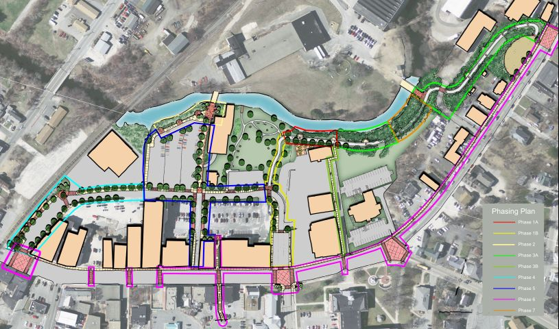
In 2011, the 1.66 acre French River Park was completed on leased land, under the direction of the Webster Office of Community Development, transforming an invasive plant and vagrant infested lot into a valued community amenity, and providing the anchor for further development of the Webster Riverwalk. In 2012, The office of Community Development contractedVanasse Hangen Brustlin Inc. (“VBH”) to produce a Concept Plan for Pedestrian Access and Circulation for the French Riverwalk and Downtown Connections. The plan is very ambitious, but can be achieved by dividing implementation into phases, the first of which is a section of the riverwalk itself.
CURRENT STATUS:
The Webster Office of Community Development has submitted its FY 2013 Mini Entitlement Grant Progam Application, requesting $238K for funding Phase 1, outlined in red above. The riverwalk will connect to French River Park and will include pedestrian and bicycle lanes in its 12 foot width. There are two river overlooks in this section. The focus will be on the ecology of the river, with native plantings and trees. The right end of this phase abuts the new police station, and final design will be coordinated with the public parking included as part of that project.
The Office of Community Development has already begun the Environmental Assessment and Floodplain Management processes, and met with public safety officials to address security and vandalism issues through the final design. The application envisions permitting and design being completed in early 2014, with construction complete later that year. An early grant decision could accelerate this schedule.
This page will be updated as events unfold.