
Home
About Us
The River
Water Quality
River Cleanup
French River Greenway
Perryville Trace
Leovich Landing
French River Park
Webster Riverwalk
Archives
Membership
Contact Us
Notices
French River Connection
First proposed in 1990, The French River Greenway is a trail system joining the Quinebaug Rail Trail to the Midstate Trail. It traverses the communities of Dudley, Oxford and Webster Massachusetts. The trail is an organizing principle for the development of such projects as the Perryville Trace and Leovich Landing. When enough of these standalone projects are completed, completion of the Greenway as a link between them will become imperitive. Most of the French River Greenway is on private but unused land, although town-owned land is used where possible. By connecting to a former trolley line route in Thompson, Connecticut, a significant loop is possible. While partly urban, much of the Greenway is in areas where it will afford habitat protection and a nature experience for users, both of which may otherwise be lost to re-industrailization of the river corridor.
Our vision includes:
A Greenway Trail which not only provides unmotorized recreational opportunities, but includes preservation of abutting natural landscapes for the benefit of native species
Links to other regional trails
Car-top access to the river for paddlers and fisherman through the development of a companion “Blueway”
Development of natural and cultural points of interest along the trail to make them safe, accessible, and informative
Improvement of urban riverfront as a catalyst to economic revitalization
Development of a shared positive identity for French River communities
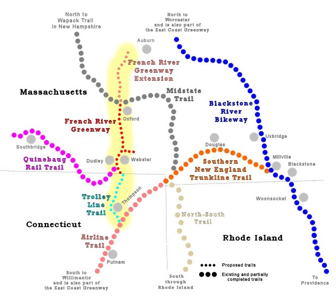
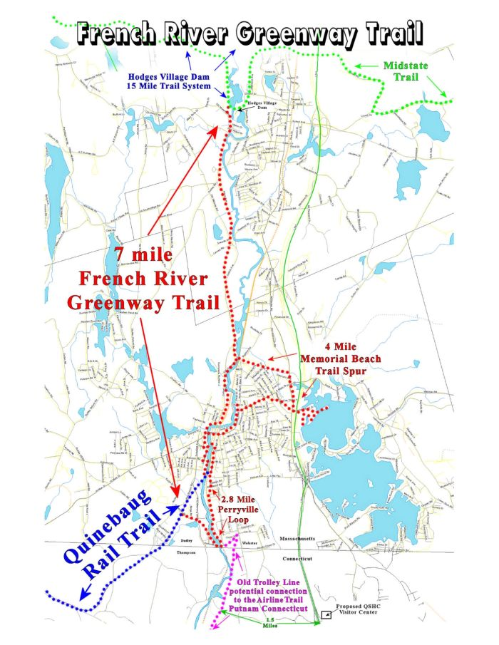
The map at left shows the French River Greenway as we envision it when fully developed, and the projects that have been identified along it.
From South to North:
The Perryville Trace is a one mile round trip trail beginning at the French River bridge on Perryville Road on the Webster side of the river, and continuing to Webster wastewater treatment plant property. It was opened in 2008 and is maintained under license from the Craver Family.
Powderhorn Path is a completely undeveloped trail segment for which the French River Connection holds a license from the owner of Stevens Mill, a Dudley landmark awaiting redevelopment.
French River Park is a 1.66 acre urban park on Davis Street in downtown Webster, opened in 2011 and maintained by the French River Connection and the Town of Webster under a 15 year lease from Holden Block LLC. The park features a boat launch, benches and picnic tables, lighting, and native plantings.
Webster Riverwalk is part of a one mile loop anchored by French River Park. It would go from the Railroad Museum past Peter Street along the river, and then return via downtown sidewalks. Under the direction of the Webster Office of Community Development, a concept was documented in 2012, and work on phase 1 is planned to be completed in 2014
Collins Cove is a riverside area more than one-half mile long which is used by paddlers as an informal boat launch, and has much potential as a wildlife viewing and historic site. Ownership of the parcels comprising the area is unclear, and means to acquire rights necessary to effectively make the land available to the public are being investigated.
Leovich Landing is a four-acre riverside parcel on Dudley Road in Oxford which was purchased by the Dudley Conservation Land Trust in 2009 and developed by the French River Connection to include a parking lot to serve as a Greenway trailhead, a boat launch, and a picnic table.
The Little River Trail is a 3000 foot trail segment on land that is owned by National Grid, extending from Leovich Landing to Charlton Road, and crossing the Little River, offering excellent view of wetlands. Some permitting for the trail has been completed, and a license agreement with National Grid is under review.